GEOTECHNICALENGINEERING
ST. CATHARINES
HomeIn-Situ TestingField density test (sand cone method)

Field Density Testing in St. Catharines: Sand Cone Method for Real Compaction Data

Practical geotechnics, field-tested.

LEARN MORE

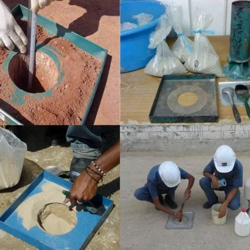
A common mistake we see on St. Catharines jobsites is assuming a few passes with a vibratory roller guarantees compaction. It doesn’t. The silty clay till that blankets much of the city — left behind by the glaciers that carved the Twelve Mile Creek valley — can look solid on the surface and still have voids 150 mm down. That’s where the field density test (sand cone method) earns its keep. We pull a direct measurement of in-place density and moisture right at the lift, typically during backfill placement, subgrade prep, or utility trench reinstatement. Before the concrete goes in or the asphalt plant dispatches the first truck, you know the number. And if it’s below the spec, you fix it then, not after the warranty period starts. On projects near the old canal or up toward the escarpment, we often pair the sand cone density check with a grain size analysis so the proctor reference curve actually matches the material being placed.

A sand cone test gives you one number that no nuclear gauge can dispute: the physical volume of a hole dug in your lift, measured with sand, not photons.

Our service areas

Our approach and scope

The kit we use on St. Catharines sites is straightforward but unforgiving if handled sloppy: a calibrated sand bottle, a base plate with a 165 mm hole, and the Ottawa sand you probably remember from your C.E.T. lab days. The technician digs out roughly 1,200 to 1,800 grams of soil through the plate, bags every grain, then pours the sand in to measure the volume of the hole. That volume, divided into the dry mass of the excavated soil, gives you the wet density. Correct it for moisture from a speedy or oven-dry, and you’ve got dry density. Compare that against the lab’s standard Proctor maximum — ASTM D698 or D1557 depending on the spec — and the percent compaction is right there. No nuclear gauge calibration drift, no lithium battery dying mid-test. When we’re working near sensitive receptors, like the wetland setbacks along Martindale Pond, the zero-radiation approach also keeps the environmental permit conditions simpler. On deeper lift evaluations, the crew often combines the test with in-situ permeability measurements so the compaction spec aligns with the site’s actual drainage behaviour.
Field Density Testing in St. Catharines: Sand Cone Method for Real Compaction Data
Technical reference — St. Catharines

Local geotechnical context

One thing we’ve learned working the north-end subdivisions and the downtown intensification projects in St. Catharines: imported granular backfill can pass a sieve analysis and still fail compaction if the moisture is off by two percent. The sand cone test catches that because it measures density in the field at the actual water content, not a lab-ideal condition. Skip the test, and you risk differential settlement under the footings, cracked partition walls six months after occupancy, or asphalt that alligators after the first freeze-thaw cycle. The clay-rich soils near the escarpment face are particularly tricky — they hold water and compact in a narrow moisture window. Our field crews watch the weather forecast religiously; a sudden Lake Ontario squall can turn a passing lift into a failing one in twenty minutes. That’s not textbook theory, that’s St. Catharines reality.

Need a geotechnical assessment?

Reply within 24h.

Email: info@geotechnicalengineering.co

Explanatory video

Relevant standards

ASTM D1556: Standard Test Method for Density and Unit Weight of Soil in Place by Sand-Cone Method, ASTM D698: Standard Proctor, ASTM D1557: Modified Proctor (where spec requires higher compactive effort), CSA A23.3: Concrete structures (references subgrade compaction acceptance), NBCC 2020: National Building Code of Canada (soil bearing and compaction provisions)

Technical parameters

ParameterTypical value
Test standardASTM D1556 / D1557 (Standard Proctor reference)
Hole diameter165 mm (6.5 in) per base plate
Typical sample mass1,200–1,800 g (fine to medium-grained soils)
Density report formatWet density, dry density, % compaction vs. Proctor curve
Moisture determinationSpeedy moisture meter (field) or oven-dry (lab backup)
Minimum lift thickness100 mm (test depth must not penetrate underlying lift)
Calibration frequencySand cone calibration checked every 14 days or 50 tests

Questions and answers

How much does a field density test cost on a St. Catharines site?

For a standard sand cone test with same-day reporting, budget between CA$120 and CA$170 per test, assuming reasonable access and volume. Mobilization outside the St. Catharines core may add a trip charge. We quote firm per-test pricing once we see the inspection test plan.

How long does the sand cone test take per location?

From setting the base plate to sealing the sample bag, about 15 to 20 minutes if the material is cooperative. Cohesive clay takes a bit longer to trim cleanly. We typically schedule one technician for eight to twelve tests per day, including travel between lifts.

Is the sand cone method accepted by the City of St. Catharines for building permit close-out?

Yes. The city’s building services division accepts ASTM D1556 field density results as part of the geotechnical close-out package, provided the testing is performed by a qualified technician under the supervision of a licensed professional engineer. We compile the results into a signed, sealed report ready for permit finalization.

Can you test granular base for a driveway or parking lot with the sand cone?

Absolutely. For typical granular A or 19 mm clear stone, the sand cone works well as long as the maximum particle size doesn’t exceed about 25 mm. If the stone is larger, we switch to a water-replacement or large-scale density method. For most residential and commercial parking areas in St. Catharines, the sand cone is the right tool.

Location and service area

We serve projects in St. Catharines and surrounding areas.

View larger map